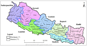
Indrawati Rural Municipality is one of the 12 local levels of Sindhupalchowk District under Bagmati Province of Nepal State, located on the bank of the Indrawati River. According to the notification dated 11-27-2073 published in the gazette by the Government of Nepal in the process of state restructuring after the constitution of Nepal 2072 made by people elected by the people, Indrawati rural municipality was formed by combining Simpal Kavre, Kunchok, Nawalpur, Bade Gaon, Sipa Pokhare, Bhotsipa and Bhimtar VDC of former. This rural municipality is named after the river Indrawati. Currently, there are 12 ward offices in the rural municipality.
Wards
- Ward No. 1 - Simpal Kavre
- Ward No. 2 - Kunchok
- Ward No. 3 - Kunchowk
- Ward No. 4 - Nawalpur
- Ward No. 5 - Bade Gaun
- Ward No. 6 - Bade Gaun
- Ward No. 7 - Sipa Pokhare
- Ward No. 8 - Sipa Pokhare
- Ward No. 9 - Bhot Sipa
- Ward No. 10 - Bhot Sipa
- Ward No. 11 - Bhimtar
- Ward No. 12 - Bhimtar
Geographical location
The total area of the rural municipality is 105.11 square kilometres at an altitude of 654 meters above sea level. Geographically, Indrawati rural municipality is spread from 85°34'35" to 85°41'34" east longitude and from 27°42'19" to 27°52'03" north latitude. The eastern border of Indrawati Rural Municipality is connected with Chautara Sangachowk Gadhi Municipality and Jugal Rural Municipality. Similarly, the western border is Melamchi Municipality, the northern border is Panch Pokhari Thangpal Rural Municipality and Jugal Rural Municipality, and the southern border is connected with Kavre District.
You can reach here from Kathmandu via Araniko highway to Jirokilo and from Jirokilo to Melamchi Helambu highway. You can also travel here through the headquarters of Chautara Bazar and other roads.
Population
According to the census of 2068, the total population of Indrawati Rural Municipality was 28517. Out of which 15141 (53.09%) were women and 13376 were men (46.91%). Similarly, according to the latest census in 2078, there is a total population of 25518. Out of which 12114 are male and 13404 are female. Similarly, there are 6584 census house numbers and 6812 family numbers. Tamang (26%), Brahmin (15.02%), Chhetri (14.67%) and other castes live in Indrawati Rural Municipality.
Local Election 2079: No. of voters
There are 25,670 voters here in the local-level elections of 2079. In which 13303 men and 12368 women. Similarly, there are 13 polling stations and 30 polling centres here.
Educational Institutions
There are community schools in all places of Indrawati Rural Municipality. Talking about the educational institutions here, there are 44 child development centres, 30 primary schools, 9 basic schools, 12 secondary schools, and 2 campuses. These educational institutions have helped to raise the educational level here.
According to the year 2068, the literacy rate of the rural municipality was 58.47 per cent. The literacy rate of women is 50.33% and the literacy rate of men is 67.83%.
Health Institutions
There are community health institutions in almost all the wards of the rural municipality. These health institutions have normal to moderate treatments. Apart from community health institutions, there are also various pharmacies and medical institutions operating in the private sector.
Among the health institutions here are Bhotsipa health post, Nawalpur health post, Bhimtar health post, Kunchok health post, Simpal Kavre health post, Sipapokhare health post, Badegaon health post etc.
Cultivable Land
Indrawati rural municipality has a total area of 9950 hectares and 5898 hectares of land is cultivable. About 62.28 square kilometres of the total area is cultivable. Many people here do farming. Crops grown here include:
Winter Crops: Mustard, Fapar, Wheat, Lentils, Maas, Wheat, Soybean, Sesame, Potato and other vegetables.
Monson Crops : rice, corn, banana, pear, millet, beans,
Apart from this, various crops such as oil palm, dal palm etc. are grown here.
Forest
About 24.67 per cent of the total area of the rural municipality i.e. 25.93 square kilometres is covered by forests. Similarly, the area covered by bushes is 13.41 square kilometres, i.e. 12.76 per cent, and the area covered by trees is 3.49 square kilometres, i.e. 3.32 per cent.
Wildlife found: Common Leopard(Panthera pardus) , Musk Deer(Moschus moschiferus) , Jackle ( Canis aureus ),
Religious and Tourism Places
Nau Lingeshwar Mahadev (1), Raneshwar Mahadev (5), Bhimsen Temple (4), Grameshwar Mahadev (8), Bhimsen Temple (4), Sundridevi Temple are famous religious places here. Similarly, many places like New Water, Nauli Danda, Gufa Danda etc. are tourist attractions. Apart from this, there are many places with potential in terms of religious and religious aspects. Although the physical structure of some tourist places has been built, the places with more tourist potential have been overshadowed.
Settlement and Market Places (Bazaar, Business area)
There are many small and medium-sized settlements or markets within Indravati rural municipality. Where economic activities take place. Simple Kavre, Golme, Kattike, Thale, Bhirkhark, Dande, Okhreni, Khyang, Aldanda, Kunchok, Kutume, Nawalpur, Salle, Lampte, Koiralatar, Dhuseni, Aselukhark, Bhadaure, Kamaltar, Dumidanda, Tulsidanda, Jamire, Bhote Sipa, Sipa Tar, Neupane, Bhimtar, etc. are the settlement and market centres here.
Contact Address
Rural Municipality Office - Nawalpur, Sindhupalchok, Bagmati, Nepal
Tel Phone - 977-16203090
Email - indrawatigaupalika@gmail.com
Website - www.indrawatimun.gov.np